Harz/O (Ost)
erstellt von admin
—
zuletzt verändert:
19.10.2020 16:44
Harz / 3233m MSL; Pilot: Tudor Văcărețu
- Name
- Tudor Vacaretu
- Datum
- 03.10.2020
- Windrichtung
- O (Ost)
- Ort des Wellensteiggebietes
- Harz
- Auslöser
- Acker / Brocken
- Erreichte Höhe
- 3233m MSL
- Zeit-Bezugssystem
- UTC
- Höhen-Bezugssystem
- QNH
- Weitere Daten
-
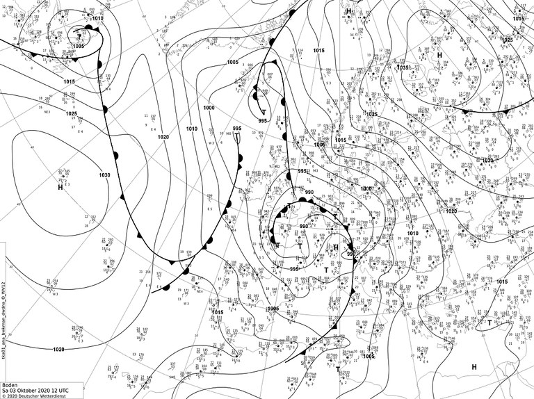
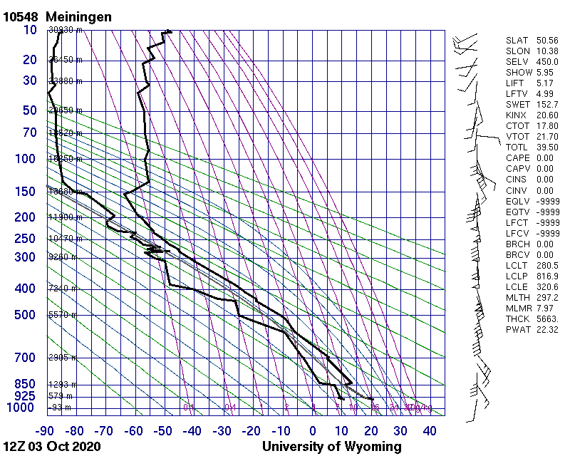
Verein: Nijmeegse Aeroclub (NijAC) Flugzeugtyp: Std Cirrus WL (15m) ------------------- Startort: Aue Bei Hattorf Startzeit: 09:28 UTC Landeort: Porta Westfalica Landezeit: 13:04 UTC ------------------- Bodenwindrichtung: 090°-120° Bodenwindstärke: 18-22 km/h ------------------- Einstieg in die Welle/n: 11:37 UTC Lee von Acker Für jedes Wellensystem: Einstieg(e) aus: F-Schlepp Einstieg(e) in Höhe: 1700 MSL Angetroffene Steigwerte: 1 m/s Erreichte Höhe(n): 3233m MSL 11:55 UTC Lee von Brocken Ausdehnung des Steiggebietes: Ortsfest ------------------- Vermuteter Auslöser: Acker; Brocken Höhenwindrichtung(en): 142°; 1628m MSL; 12:31 UTC Höhenwindstärke(n): 53 km/h - Freier Bericht
- Many thanks to Mapi and the Aue Bei Hattorf team for the nice day and warm welcome on their cozy airfield. The wave started weak in the morning, but later it improved and was just enough to enjoy the nice weather and the view above the Harz from 3200m. When I felt I reached the top of the wave I headed towards Porta Westfalica, knowing that the wind would rotate south, and hoping that my timing would be good for connecting to the Porta ridge. When I reached Porta the wind was still parallel to the ridge (and it rotated only 2 hours later), which did not make the connection possible. But the long glide was still very enjoyable. And now I was on the right airfield for a nice ridge day on Sunday. Thanks to Johannes and Aero-Club Minden for their welcome and help at Porta :). Many thanks to Langen Info and Radar for their cooperation and clearance above FL100.
IGC Datei herunterladen: 0a3x96k1.igc
Foto1: P1010317.jpeg

Foto2: P1010325.jpeg

Foto3: P1010347.jpeg

https://www.onlinecontest.org/olc-3.0/gliding/flightinfo.html?dsId=8201604
https://www.onlinecontest.org/olc-3.0/gliding/flightinfo.html?dsId=8201688
https://www.onlinecontest.org/olc-3.0/gliding/flightinfo.html?dsId=8201629
https://www.onlinecontest.org/olc-3.0/gliding/flightinfo.html?dsId=8201619
https://www.onlinecontest.org/olc-3.0/gliding/flightinfo.html?dsId=8201609
Werratal:
https://www.onlinecontest.org/olc-3.0/gliding/flightinfo.html?dsId=8201624
Quelle: http://www2.wetter3.de/Archiv/archiv_dwd.html
Artikelaktionen
